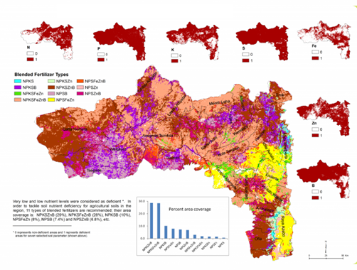
ESSP’s efforts to build capacity and disseminate knowledge in areas that are critical to development, are manifested in the soil mapping program – the Ethiopian Soil Information System (EthioSIS) - driven by the Ethiopian government. ESSP seconded Hailu Shiferaw, a GIS expert, to work with the Agricultural Transformation Agency (ATA) and the Ministry of Agriculture (MoA) to capture data on Ethiopian soils, to build an extensive database for mapping the soil fertility, and to coordinate the GIS analyses in the EthioSIS team to produce the final digital soil mapping and printable Soils Atlases. Each regional state has fertility status maps, and at Kebele level, fertilizer recommendation maps.
This advancement means that the government can now more appropriately tailor fertilizer distribution, and farmers can apply a custom-blend fertilizer to mitigate the depletions of nutrients in the soil using a map to locate depleted areas. Eventually, the nutrients of these replenished soils will find their way into the food system and impact human health by providing vital minerals. Read more.
